
Standards for seismic stations and data management
Network Code: AlpArray Temporary Stations use network code Z3. Exception: Additional Experiments, such as the EASI Swath, with network code XT.
Channel Naming Convention: if sensor orientation is known or suspected to be more than 5degrees from N/E, instead of HH[ZNE] use HH[Z23]
Sampling Rates: AlpArray Z3 stations should be sampled at a minimum of 100sps. Higher sampling rates are allowed. Networks can decide whether to also offer downsampled data streams, eg BH? @ 20/40/50sps, LH? @ 1sps.
Technical strategy: AlpArray technical strategy
Station naming convention: AASN Station naming
Station Description / Site Name convention: AlpArray Z3 stations should follow the station desciption naming strategy where possible: <nearby town / feature>, region, country. Examples: A062A - Arbedo Castione, Alpe di Gesero, TI, Switzerland; A015A - Langauhaeuser, Niederoesterreich, Austria
1- ensure any Z3 metadata included in your inventory is restricted.
2- pass to SED an inventory dump for the Z3 stations they are responsible for. SED team add the metadata to EIDA as we are responsible for the Z3 network.
Station book
The Orfeus Station Book (www.orfeus-eu.org/stationbook) provides station information from every station included in EIDA, including all AlpArray Seismic Network Stations. Basic information from the EIDA database is fixed, but additional site information, such as geology, housing, as well as site photos, can be added manually. The basic information is updated every day to reflect new stations.
The station book provide the AlpArray community with an easy way to centrally collect and display all relevant information collected for the AlpArray temporary installations. It is a method to ensure a complete, homogeneous, and detailed database of the temporary installations.
All the institutes managing Z3 stations (backbone) and complementary experiments (EASi, ..) are requested to review and update the station pages under their control in the Orfeus Station Book (ie this is not the responsibility of the EIDA node, but the institution operating the stations). This should be done whenever new stations are added.
The station operator needs a username and a pwd (provided in a separate e-mail) in order to modify the content of the database. Modify only the stations that you are currently operating!
Go to www.orfeus-eu.org/stationbook, click on “Manage Network(s)” and login. With the AlpArray password, you are only authorised to manage the Z3 network. Click on the “Manage” blue button.

Select a station from the map or from the list below the map and click on “Manage” button.

Now you have access at the station page
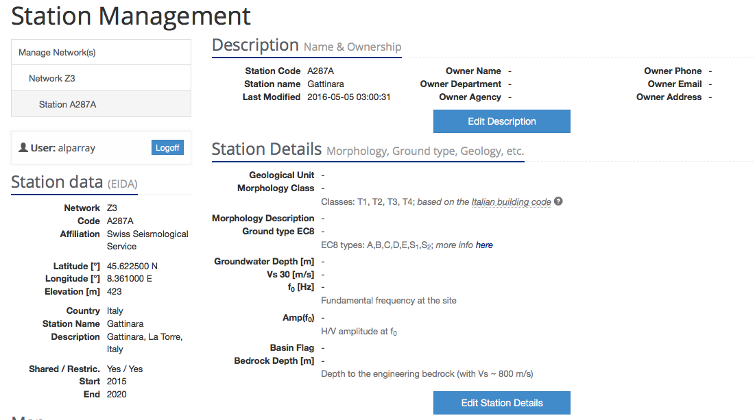
“Station data” on the top left of the page is not editable since it contains the fixed information stored in the station metadata from EIDA.
“Description” - not required by the AlpArray project. It is optional to add information here like the institute that owns and operates the station or the email.
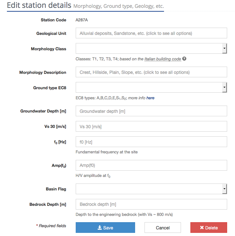
“Station details”: strongly recommended including the information regarding
- Geological unit
- Morphology class
- Morphology description
- Basin Flag
All the other fields are optional.
Save your changes by pressing the save button.
“Manage sensor location”: it is mandatory to include housing class and housing description.
Press “manage” and then “Edit Location Details”.


All the fields are mandatory and they should follow the guidelines below (guidelines developed and used by SED).
"Housing Class":
| Cave | a natural chamber or series of chambers in the earth or in the side of a hill or cliff |
| Tunnel | a man-made subterranean gallery typically with cylindrical shape with diameter between 1-10m, allowing human passage |
| Borehole | a small-diameter (up to 1m, not fit for human passage) typically vertical well hosting a sensor or series of sensors |
| Underground shelter | a man-made buried (typically concrete) structure for human presence or storage |
| Free field | for sensors located less than 5m below surface and further than 1 x height of the surrounding structures |
| Urban free field | for sensors located less than 5m below surface and within 1 x height of the surrounding structures. Can often be located inside 1-story buildings |
| Building | for sensors located inside the footprint of a building larger than 1-storey |
| Bridge/Dam/Other Structures | |
"Housing description" – this is free text, but you can follow the following guidelines
| Cave | Sensor in cave [x m] directly below free surface, [y m] from nearest entrance. [proximity to major feature e.g. at foot of dam] [other interesting info / usage (e.g. abandoned military bunker / steep slope above)] [sensor coupling information (e.g. Sensor placed on 40cm high concrete pedestal on rock)] |
| Tunnel | Sensor in tunnel [x m] directly below free surface, [y m] from nearest entrance. [proximity to major feature e.g. at foot of dam] [other interesting info / usage (e.g. abandoned military bunker / steep slope above)] [sensor coupling information (e.g. Sensor placed on 40cm high concrete pedestal on rock)] |
| Borehole | casing: [open / metal]; casing length: [x m]; diameter: [x cm]; locking mechanism: [type]; [wet / dry] |
| Underground shelter | Sensor in underground shelter [x m] directly below free surface, [y m] from nearest entrance. [proximity to major feature e.g. at foot of dam] [other interesting info / usage (e.g. abandoned military bunker / steep slope above)] [sensor coupling information (e.g. Sensor placed on 40cm high concrete pedestal on rock)] |
| Free field | big/small pot / concrete vault [other interesting info / (e.g. steep slope above)] [sensor coupling information (e.g. Sensor placed directly on concrete base on rock / soil / sediment / …)] |
| Urban free field | {Option 1 - Vault:} big/small pot concrete vault [type of building close-by] [other interesting info / usage (e.g. abandoned military bunker / steep slope above)] [sensor coupling information (e.g. Sensor placed on 40cm high concrete pedestal on concrete floor on rock / soil / sediment / …)]. {Option 2 - inside small structure:} Sensor in [basement / group floor] in [e.g. NE corner / centre] of 1 story building with building footprint [a]m x [b]m. Building type: [concrete/steel/brick/wood]. Building density: [dense urban town / village / isolated building]. Building usage: [Building used for storage / abandoned / inhabited / car garage…]. Sensor coupling information (e.g. Sensor placed on 40cm high concrete pedestal on exposed rock)] |
| Building | Sensor in [basement / group floor] in [e.g. NE corner / centre] of [X] story building with building footprint [a]m x [b]m. Building type: [concrete/steel/brick/wood]. Building density: [dense urban town / village / isolated building]. Building usage: [Building used for storage / abandoned / inhabited / car garage…]. Sensor coupling information (e.g. Sensor placed on 40cm high concrete pedestal on exposed rock)] |
| Bridge/Dam/Other Structures | |
Examples
Housing Class: Urban free-field
Housing description: Sensor in ground floor in NE edge of 1 story structure with irregular footprint 3m x 4m. Building type: concrete and brick frame, single story mostly buried, flat roof with public parking parking. Sensor on exposed edge with steep slope below. Building density: isolated structure on hill top near old church and tower. Building usage: parking platform below rarely used, sensor room rarely used for storage. Sensor coupling information: Sensor placed directly on concrete floor.Station: Z3.A050A
Housing Class: Building
Housing description: Sensor in buried basement of 3 story building and building footprint 15m x 13m. Building type: concrete and bricks. Building density: building in isolated small village. Building usage: used as office during working hours. Sensor coupling information: sensor placed on concrete floor.Station: Z3.A060A
Housing Class: Free-field
Housing description: Plastic pot. Sensor placed on a metal plate fixed directly on concrete pad at base of plastic vault.
"In Building": is the sensor in a building?
"Number of stories": If the sensor is located within a building, please give here the number of stories of the building
"Distance to buildings": populate only for Housing Class=”Urban free-field”; Distance to the closest building or other structure taller than 1-story high.
Click on the “Save” button.
“Station pictures”: from 3 to 6 pictures. We strongly recommend the following pictures: one (ore two) with the sensor and the digitizer, one with the final station setup (including the thermal isolation) and one with the site location from outside. Any other relevant picture that better describe the site is welcomed (antennas, solar panels)
Click on the “Save” button.
“Borehole” not needed.